


Nereson Twp. Voting District, Roseau County, Minnesota
About
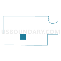
Outline

Summary
| Unique Area Identifier | 604152 |
| Name | Nereson Twp. Voting District |
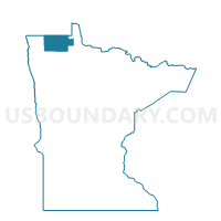
| County | Roseau County |
| State | Minnesota |
| Area (square miles) | 36.25 |
| Land Area (square miles) | 36.25 |
| Water Area (square miles) | 0.00 |
| % of Land Area | 100.00 |
| % of Water Area | 0.00 |
| Latitude of the Internal Point | 48.67340850 |
| Longtitude of the Internal Point | -95.92962300 |
Maps

Graphs
Select a template below for downloading or customizing gragh for Nereson Twp. Voting District, Roseau County, Minnesota


Neighbors
Neighoring Voting District (by Name) Neighboring Voting District on the Map
- Barnett Twp. Voting District, Roseau County, MN
- Grimstad Twp. Voting District, Roseau County, MN
- Huss Twp. Voting District, Roseau County, MN
- Palmville Twp. Voting District, Roseau County, MN
- Poplar Grove Twp. Voting District, Roseau County, MN
- Stafford Twp. Voting District, Roseau County, MN
- Stokes Twp. Voting District, Roseau County, MN
Top 10 Neighboring County Subdivision (by Population) Neighboring County Subdivision on the Map
- Stafford township, Roseau County, MN (284)
- Stokes township, Roseau County, MN (215)
- Grimstad township, Roseau County, MN (146)
- Barnett township, Roseau County, MN (139)
- Huss township, Roseau County, MN (120)
- Poplar Grove township, Roseau County, MN (82)
- Nereson township, Roseau County, MN (58)
- Palmville township, Roseau County, MN (39)